Professional Aerial Real Estate and Construction Surveys in Mumbai
Get the complete picture of your project from above. I provide precise, high-resolution aerial photography and 4K videography to showcase developments or monitor construction progress across the city.
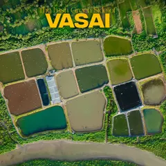
A clear aerial shot of the Tree House High School campus in Virar. This image is perfect for an institutional portfolio, showing the school building, playground, and surrounding neighborhood in a single, informative view.
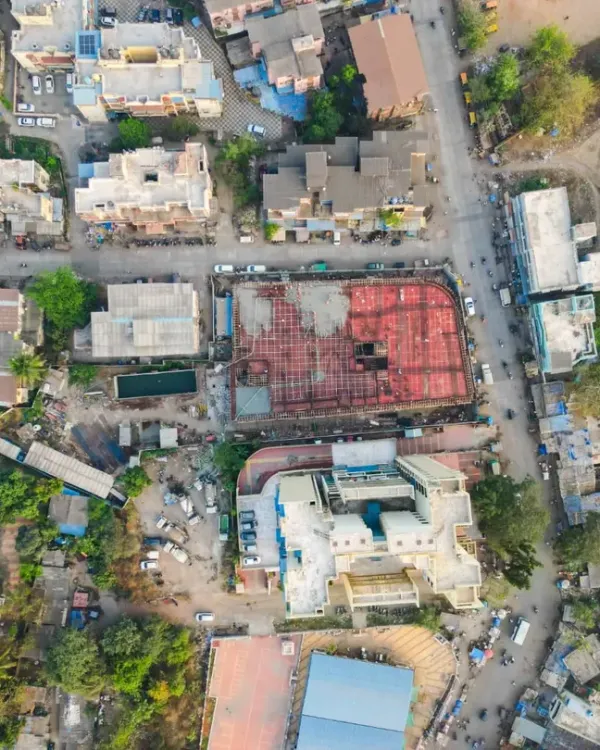
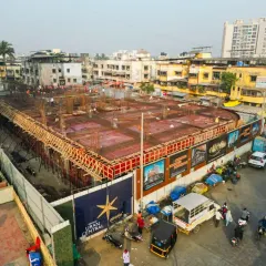
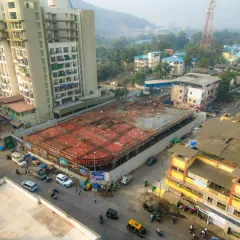
This aerial photo documents the construction of the Dadar viewing deck. It's a prime example of using drone photography for monitoring progress on public infrastructure projects, showing the structural framework and worksite.
An aerial view of the completed Dadar viewing deck, showcasing the final product. This type of shot is ideal for marketing and promotional materials for tourism or civic projects, highlighting the new attraction against the city skyline.
A panoramic shot featuring the Dadar viewing deck, demonstrating its value as a recreational spot with stunning views of the coast and city. This is useful for real estate marketing of nearby properties or for promoting tourism.
About Real Estate & Commercial Surveys
When you are showcasing a commercial property or monitoring a construction site, standard ground-level shots often miss the scale of the project. My drone surveys provide clear, legal, and high-resolution perspectives—from top-down site mapping to panoramic progress reports—giving you the exact visual data you need for stakeholders, marketing brochures, or site documentation.
Aerial imagery has become essential for construction management and real estate marketing. Whether you are tracking the structural evolution of a public project like the Dadar viewing deck or showcasing the expansive campus of an institution like Tree House High School in Virar, you need angles that clearly define the site boundaries and context.
Why Choose Professional Drone Surveys
- Technical Precision: I use professional DJI drone gear capable of 4K video and 48MP stills. This ensures that every survey provides sharp, distortion-free images useful for detailed planning.
- Legal Compliance: Operating as a DGCA-certified pilot, I ensure all flights are conducted legally within designated green zones, keeping your project safe from regulatory issues.
- Efficient Workflow: For site surveys, I offer instant transfer via cable on-site or cloud links within 24 hours. You get the raw 4K footage or high-res stills without the wait, allowing your team to move to the next phase of planning immediately.
Applications for Your Project
- Construction Progress Monitoring: Regularly scheduled flights help you document construction milestones, verify site conditions, and share progress updates with investors.
- Real Estate Marketing: High-altitude shots capture the property's relationship with its surroundings, highlighting proximity to the coastline, main roads, or green spaces.
- Institutional Mapping: Aerial views are ideal for educational campuses, allowing you to showcase the full layout of playgrounds, buildings, and infrastructure in a single, comprehensive frame.
From the busy, evolving landscape of Mumbai to sites across Maharashtra, I help you see the bigger picture. If your site involves complex environments, I can also include a visual observer to ensure safety during the operation.
Similar work from other experts
Browse through Curated picks from other experts on mytribe
 5
5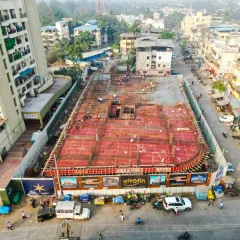
Professional Architectural and Project Documentation
Construction and Development Site Drone Monitoring
 5
5

Aerial Construction Monitoring & Drone Photography
Cinematic Aerial Drone Filmmaking in Mumbai
 63
63
Aerial Drone Photography for Landscape Projects
Cinematic Drone Photography and Aerial Cinematography
Looking for a different kind of shoot?
Use our search to find the right visual service for your project needs.
More from Aerial Photography & Videography by Photokablega
More services by Photokablega